File:The Fens England map.svg

File originale (file in formato SVG, dimensioni nominali 1 740 × 1 585 pixel, dimensione del file: 1,59 MB)
| Questo file e la sua pagina di descrizione (discussione · modifica) si trovano su Wikimedia Commons (?) |
Dettagli
| Descrizione |
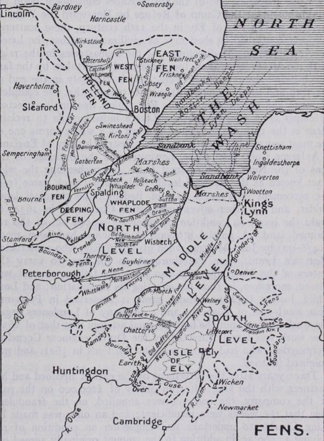
English: Map of The Fens England, places, levels, plains and and drains.
|
||||||||||||||
| Data | |||||||||||||||
| Fonte |
Opera propria basata su: Information from:
|
||||||||||||||
| Autore | Goran_tek-en | ||||||||||||||
| Licenza (Riusare questo file) |
Questo file è disponibile in base alla licenza Creative Commons Attribuzione-Condividi allo stesso modo 4.0 Internazionale Attribuzione: Goran_tek-en
|
||||||||||||||
| Altre versioni |
|
||||||||||||||
| SVG sviluppo | Questa grafica vettoriale è stata creata con Inkscape. |
||||||||||||||


| Posizione del soggetto | | Posizione di questa e altre immagini su: OpenStreetMap |
|---|

Cronologia del file
Fare clic su un gruppo data/ora per vedere il file come si presentava nel momento indicato.
| Data/Ora | Miniatura | Dimensioni | Utente | Commento | |
|---|---|---|---|---|---|
| attuale | 14:22, 19 apr 2024 | | 1 740 × 1 585 (1,59 MB) | Goran tek-en | aded city requested by MOTORAL1987 |
| 18:30, 18 apr 2024 |  | 1 740 × 1 585 (1,59 MB) | Goran tek-en | added city requested by MOTORAL1987 | |
| 16:09, 18 apr 2024 |  | 1 740 × 1 585 (1,58 MB) | Goran tek-en | added rivers requested by MOTORAL1987 | |
| 19:07, 16 apr 2024 |  | 1 740 × 1 585 (1,58 MB) | Goran tek-en | added stuff requested by MOTORAL1987 | |
| 20:00, 15 apr 2024 |  | 1 740 × 1 585 (1,57 MB) | Goran tek-en | stuff added as requested by MOTORAL1987 | |
| 17:20, 13 apr 2024 |  | 1 740 × 1 585 (1,57 MB) | Goran tek-en | added village requested by MOTORAL1987 | |
| 17:42, 7 apr 2024 |  | 1 740 × 1 585 (1,56 MB) | Goran tek-en | added villages, removed colors agreed with MOTORAL1987 | |
| 14:25, 1 apr 2024 |  | 1 740 × 1 585 (1,69 MB) | Goran tek-en | {{Information |description ={{en|Map of The Fens England, places, levels, plains and and drains.}} {{Institution |wikidata=Q1404827}} |date =2024-04-01 |source ={{Own based|Map of The Fens.jpg|Map of the Fens.svg|b1=Lovell Johns Ltd|b2=Rcsprinter123}} {{Own}} <br> {{own using}} [https://www.openstreetmap.org/#map=10/53.0111/0.3694 OpenStreetMap]<br> *[https://johnknifton.files.wordpress.com/2018/05/fens.jpg johnknifton.files.wordpress.com] Information from: *[https://... |
Pagine che usano questo file
La seguente pagina usa questo file:
Utilizzo globale del file
Anche i seguenti wiki usano questo file: