File:Thames Tunnel-route.png
Vai alla navigazione
Vai alla ricerca

Dimensioni di questa anteprima: 325 × 599 pixel. Altre risoluzioni: 130 × 240 pixel | 260 × 480 pixel | 416 × 768 pixel | 555 × 1 024 pixel | 2 168 × 3 998 pixel.
File originale (2 168 × 3 998 pixel, dimensione del file: 7,16 MB, tipo MIME: image/png)
| Questo file e la sua pagina di descrizione (discussione · modifica) si trovano su Wikimedia Commons (?) |
Dettagli
| Descrizione |
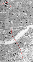
English: Map of the underground routing and approaches (highlighted in RED) to the Thames Tunnel, London UK, beginning at Whitechapel station and continuing south under Shadwell until reaching Wapping railway station, thence through the Thames Tunnel under the River Thames to Rotherhithe station and still underground passes beneath Southwark until it emerges from the ground near Deptford Road Station. |
| Data | 29 luglio 2019 (data di caricamento) |
| Fonte | L'autore del caricamento su Wikimedia Commons} ha ricevuto questo da chi ha creato l'opera/chi detiene i diritti via photosubmissions. |
| Autore | Route highlighting in RED by Jonathan Bluestone, derived from an Ordnance Survey map published ca. 1889 |
| Licenza (Riusare questo file) |
Licenza
Derivative work:
| Questo file è reso disponibile nei termini della licenza Creative Commons CC0 1.0 Universal. | |
| La persona che ha associato un'opera con questo atto legale ha donato tale opera nel pubblico dominio rinunciando a tutti i diritti sull'opera in tutto il mondo, inclusi tutti i diritti connessi o altri diritti simili, per quanto permesso dalla legge. Puoi copiare, modificare, distribuire ed utilizzare l'opera, anche a fini commerciali, senza chiedere alcun permesso.
|
Map:
This work is an Ordnance Survey map over 50 years old, which is covered by Crown Copyright which in this case expires 50 years after publication. Ordnance Survey does however ask that they be credited and that the date of publication be given.
Any ancillary rights gained through the creation of the electronic version are granted as freely usable under any circumstances.
|
Quest'opera d'arte creata dal Governo del Regno Unito è nel pubblico dominio a causa di una delle seguenti motivazioni:
HMSO ha dichiarato che la cessazione del Crown copyright si applica in tutto il mondo (ref: HMSO Email Reply)
|
 |
Cronologia del file
Fare clic su un gruppo data/ora per vedere il file come si presentava nel momento indicato.
| Data/Ora | Miniatura | Dimensioni | Utente | Commento | |
|---|---|---|---|---|---|
| attuale | 14:36, 29 lug 2019 | | 2 168 × 3 998 (7,16 MB) | JGHowes | {{Information |Description={{en|1=Map of '''{{w|Thames Tunnel}}''', London UK. The underground portion is highlighted in <font color=red>'''''RED'''''</font color> beginning at {{w|Whitechapel station}} and continuing south under Shadwell until it reaches the Thames at {{w|Wapping railway station}}, where it goes under the Thames to {{w|Rotherhithe station}} and still underground passes beneath Southwark until it emerges from the ground close to Deptford Road Station.}} |Source={{author sourc... |
Pagine che usano questo file
La seguente pagina usa questo file:
Utilizzo globale del file
Anche i seguenti wiki usano questo file:
- Usato nelle seguenti pagine di en.wikipedia.org:
- Usato nelle seguenti pagine di eo.wikipedia.org:
- Usato nelle seguenti pagine di es.wikipedia.org: