File:River Deltas, Lake Ayakum, Tibet.JPG
Vai alla navigazione
Vai alla ricerca

Dimensioni di questa anteprima: 800 × 532 pixel. Altre risoluzioni: 320 × 213 pixel | 640 × 425 pixel | 1 024 × 681 pixel | 1 280 × 851 pixel | 2 560 × 1 701 pixel | 4 288 × 2 850 pixel.
File originale (4 288 × 2 850 pixel, dimensione del file: 2,74 MB, tipo MIME: image/jpeg)
| Questo file e la sua pagina di descrizione (discussione · modifica) si trovano su Wikimedia Commons (?) |
Dettagli
| Descrizione |
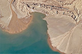
English: This astronaut photograph highlights two river deltas formed along Lake Ayakum's south-western shoreline. Gray to tan surfaces indicate prior positions of the river channels; the uniform coloration and smooth texture suggest that they are relatively old and now inactive. By contrast, the younger and currently active delta surfaces have reddish-brown sediment and visible river channels.
Lateral channel migration is particularly evident in the approximately 8-kilometer wide active delta at image upper left. The reddish color of the fresh sediment may indicate a change from the sources that formed the older parts of the deltas. It might indicate weathering and soil formation on the older deposits. It could even be a sign of episodic inputs of dust or other material to the river catchments. |
| Data | |
| Fonte | NASA Earth Observatory |
| Autore | ISS Expedition 27 crew |
| Luogo dello scatto | | Posizione di questa e altre immagini su: OpenStreetMap |
|---|
Questa immagine o filmato è stato catalogato dal Johnson Space Center della National Aeronautics and Space Administration (NASA) degli Stati Uniti d'Americacon il Photo ID: ISS027-E-16922.Questo tag non indica lo status del copyright dell'opera ad esso associato. È quindi richiesto un normale tag di copyright. Vedi Commons:Licenze per maggiori informazioni. Altre lingue:
|
Image acquired with a Nikon D2Xs digital camera using a 400 mm lens, and is provided by the ISS Crew Earth Observations experiment and Image Science & Analysis Laboratory, Johnson Space Center.
Licenza
| Questo file è nel pubblico dominio perché creato dalla NASA. La politica sul copyright della NASA afferma che «il materiale della NASA non è protetto da copyright a meno che non sia specificato altrimenti». (NASA copyright policy e JPL Image Use Policy). | ||
 |
Attenzione:
|
| Annotazioni | Questa immagine è annotata: Vedi le annotazioni su Commons |
Cronologia del file
Fare clic su un gruppo data/ora per vedere il file come si presentava nel momento indicato.
| Data/Ora | Miniatura | Dimensioni | Utente | Commento | |
|---|---|---|---|---|---|
| attuale | 13:50, 12 mag 2011 | | 4 288 × 2 850 (2,74 MB) | Originalwana | {{Information |Description ={{en|1=This astronaut photograph highlights two river deltas formed along Lake Ayakum's south-western shoreline. Gray to tan surfaces indicate prior positions of the river channels; the uniform coloration and smooth |
Pagine che usano questo file
La seguente pagina usa questo file:
Utilizzo globale del file
Anche i seguenti wiki usano questo file:
- Usato nelle seguenti pagine di ceb.wikipedia.org:
- Usato nelle seguenti pagine di en.wikipedia.org:
- Usato nelle seguenti pagine di es.wikipedia.org:
- Usato nelle seguenti pagine di fa.wikipedia.org:
- Usato nelle seguenti pagine di pa.wikipedia.org:
- Usato nelle seguenti pagine di vi.wikipedia.org: