File:Nares strait border (Kennedy channel).png

File originale (1 765 × 1 249 pixel, dimensione del file: 124 KB, tipo MIME: image/png)
| Questo file e la sua pagina di descrizione (discussione · modifica) si trovano su Wikimedia Commons (?) |
.png?uselang=it)
.png)
.png&action=edit)

|
Questa immagine (categorizzazione automatica: map) o tutte le immagini in questa categoria o galleria dovrebbero essere ricreate usando grafica vettoriale come file SVG. Questo offre diversi vantaggi: vedi Commons:Media for cleanup per maggiori informazioni. Se è disponibile una versione in formato SVG di questa immagine, per favore caricala. Dopo aver caricato un file SVG, sostituisci questo avviso con il template {{Vector version available|nome_immagine.svg}}.
|
| Descrizione |
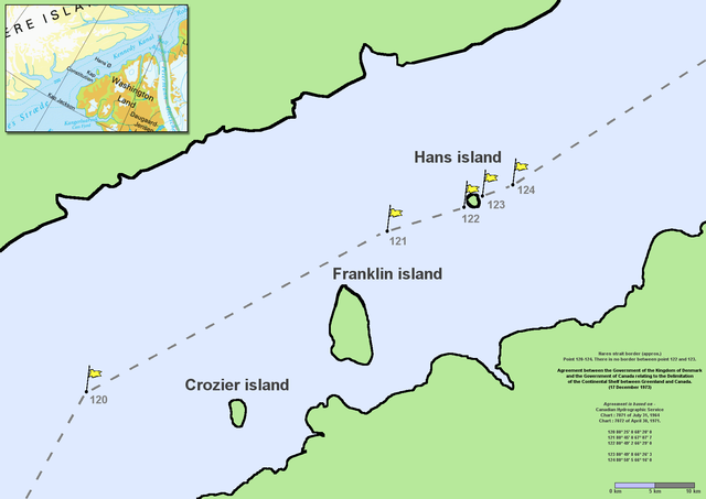
en:Nares Strait (en:Kennedy Channel) border (approx.) Point 120–124. There is no border between point 122 and 123. Agreement between the Government of the Kingdom of Denmark and the Government of Canada relating to the Delimitation of the Continental Shelf between Greenland and Canada. (17 December 1973) Agreement is based on en:Canadian Hydrographic Service charts 7071 of July 31, 1964 and 7072 of April 30, 1971
|
| Data | Commons upload by File Upload Bot (Magnus Manske) 10:54, 7 June 2006 (UTC) |
| Fonte |
Questo file è disponibile in base alla licenza Creative Commons Attribuzione 2.5 Generico
|
| Autore | User Twthmoses on en.wikipedia |
Originally from en.wikipedia; description page is (was) here
.png)
- 06:02, 29 July 2005 Twthmoses 1765x1249 (196,934 bytes) ([[:en:Nares strait]] border (approx.) Point 120-124. There is no border between point 122 and 123. ''Agreement between the Government of the Kingdom of Denmark and the Government of Canada relating to the Delimitation of the Continental Shelf between Greenla)
Cronologia del file
Fare clic su un gruppo data/ora per vedere il file come si presentava nel momento indicato.
| Data/Ora | Miniatura | Dimensioni | Utente | Commento | |
|---|---|---|---|---|---|
| attuale | 12:32, 24 mar 2015 | | 1 765 × 1 249 (124 KB) | RokerHRO | optipng -o7 -i0 → 35.36% decrease |
| 12:54, 7 giu 2006 |  | 1 765 × 1 249 (192 KB) | File Upload Bot (Magnus Manske) | {{Information| |Description= en:Nares Strait (en:Kennedy Channel) border (approx.) Point 120-124. There is no border between point 122 and 123. ''Agreement between the Government of the Kingdom of Denmark and the Government of Canada relating |
Pagine che usano questo file
Le seguenti 4 pagine usano questo file:
Utilizzo globale del file
Anche i seguenti wiki usano questo file:
- Usato nelle seguenti pagine di ar.wikipedia.org:
- Usato nelle seguenti pagine di az.wikipedia.org:
- Usato nelle seguenti pagine di bcl.wikipedia.org:
- Usato nelle seguenti pagine di be-tarask.wikipedia.org:
- Usato nelle seguenti pagine di be.wikipedia.org:
- Usato nelle seguenti pagine di bn.wikipedia.org:
- Usato nelle seguenti pagine di ca.wikipedia.org:
- Usato nelle seguenti pagine di ceb.wikipedia.org:
- Usato nelle seguenti pagine di cs.wikipedia.org:
- Usato nelle seguenti pagine di da.wikipedia.org:
- Usato nelle seguenti pagine di de.wikipedia.org:
- Usato nelle seguenti pagine di en.wikipedia.org:
- Usato nelle seguenti pagine di en.wikiversity.org:
- Usato nelle seguenti pagine di eo.wikipedia.org:
- Usato nelle seguenti pagine di es.wikipedia.org:
- Usato nelle seguenti pagine di et.wikipedia.org:
- Usato nelle seguenti pagine di fa.wikipedia.org:
- Usato nelle seguenti pagine di fr.wikipedia.org:
- Usato nelle seguenti pagine di fy.wikipedia.org:
- Usato nelle seguenti pagine di he.wikipedia.org:
Visualizza l'utilizzo globale di questo file.
.png)
.png)