File:NAS Cubi Point and NS Subic Bay.jpg
Vai alla navigazione
Vai alla ricerca

Dimensioni di questa anteprima: 800 × 547 pixel. Altre risoluzioni: 320 × 219 pixel | 640 × 437 pixel | 1 024 × 700 pixel | 1 280 × 875 pixel | 2 780 × 1 900 pixel.
File originale (2 780 × 1 900 pixel, dimensione del file: 3,45 MB, tipo MIME: image/jpeg)
| Questo file e la sua pagina di descrizione (discussione · modifica) si trovano su Wikimedia Commons (?) |
Dettagli
| Descrizione |
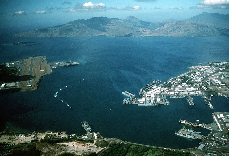
English: Aerial view of the U.S. Navy Naval Station Subic Bay, Philippines, circa in 1990, with Naval Air Station Cubi Point visible on the left.
This photo was most probably taken in January of 1991, during the build-up to Operations DESERT SHIELD & DESERT STORM, but before the 12 June 1991 eruption of Mt. Pinatubo. In addition to the USS Ranger, moored at Leyte Pier, a Tarawa-class LHA is visible in the image, tied up in the maintenance area of the Subic Bay Naval Shipyard. The only Tarawa-class ship in the WestPac at the time was the Tarawa. The other west coast LHAs were both in port undergoing overhaul/maintenance in California (Belleau Wood (LHA 3) in San Diego and Peleliu (LHA 5) in Long Beach. Also visible at Alava Pier, above the Tarawa, is an Iwo Jima-class LPH, and at least seven other amphibious ships (LPD, LSD, LST). This is consistent with two full Amphibious Readiness Groups (ARGs) deployed for Operation DESERT SHIELD/DESERT STORM.Note: The photo is dated, incorrectly, as "1 January 1990". The aircraft carrier USS Ranger (CV 61) is docked at NAS Cubi Point. Ranger was deployed to the Western Pacific from 24 February to 24 August 1989 and to the Western Pacific and the Indian Ocean during the 1991 Gulf War from 8 December 1990 to 8 June 1991. |
|||
| Data | circa | |||
| Fonte |
|
|||
| Autore | PH1(Nac) David R. Sanner, U.S. Navy |
| Luogo dello scatto | | Posizione di questa e altre immagini su: OpenStreetMap |
|---|
Licenza
Questo file multimediale è un'opera realizzata da un marinaio o da un dipendente della Marina degli Stati Uniti durante l'assolvimento dei suoi doveri ufficiali. Essendo un'opera del governo federale USA, il file è nel pubblico dominio.
|
 | |
| Questo file è stato identificato come libero da restrizioni conosciute riguardanti le leggi sul copyright, compresi tutti i diritti connessi e vicini. | ||
Cronologia del file
Fare clic su un gruppo data/ora per vedere il file come si presentava nel momento indicato.
| Data/Ora | Miniatura | Dimensioni | Utente | Commento | |
|---|---|---|---|---|---|
| attuale | 03:27, 25 apr 2007 | | 2 780 × 1 900 (3,45 MB) | Dual Freq | {{Information |Description= |Source=[http://www.dodmedia.osd.mil/Assets/Still/1991/Navy/DN-ST-91-11630.JPEG ID:DN-ST-91-11630] |Author=Camera Operator: PH1(NAC) DAVID R. SANNER </br>Service Depicted: Navy An aerial view of the station and, to the left, N |
Pagine che usano questo file
La seguente pagina usa questo file:
Utilizzo globale del file
Anche i seguenti wiki usano questo file:
- Usato nelle seguenti pagine di arz.wikipedia.org:
- Usato nelle seguenti pagine di ca.wikipedia.org:
- Usato nelle seguenti pagine di ceb.wikipedia.org:
- Usato nelle seguenti pagine di en.wikipedia.org:
- Usato nelle seguenti pagine di fr.wikipedia.org:
- Usato nelle seguenti pagine di fr.wikivoyage.org:
- Usato nelle seguenti pagine di ja.wikipedia.org:
- Usato nelle seguenti pagine di nl.wikipedia.org:
- Usato nelle seguenti pagine di pl.wikipedia.org:
- Usato nelle seguenti pagine di pt.wikipedia.org:
- Usato nelle seguenti pagine di sv.wikipedia.org:
- Usato nelle seguenti pagine di uk.wikipedia.org:
- Usato nelle seguenti pagine di vi.wikipedia.org:
- Usato nelle seguenti pagine di www.wikidata.org:
- Usato nelle seguenti pagine di zh.wikipedia.org: