File:Munster Tabula Novarum Insularum 1540 UTA.jpg
Vai alla navigazione
Vai alla ricerca

Dimensioni di questa anteprima: 777 × 600 pixel. Altre risoluzioni: 311 × 240 pixel | 622 × 480 pixel | 995 × 768 pixel | 1 280 × 988 pixel | 2 560 × 1 975 pixel | 3 674 × 2 835 pixel.
File originale (3 674 × 2 835 pixel, dimensione del file: 1,93 MB, tipo MIME: image/jpeg)
| Questo file e la sua pagina di descrizione (discussione · modifica) si trovano su Wikimedia Commons (?) |
Dettagli
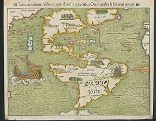
| Titolo |
Latina: Tabula Novarum Insularum |
||||||||||||||||||||||||||
| Descrizione |
English: Religion and politics are often closely allied, and this was especially the case in the sixteenth century. In this famous map, the Spanish flag flies prominently in the West Indies, while the Portuguese flag dominates the south Atlantic – reflecting pronouncements by Pope Alexander VI in 1493 and the Treaty of Tordesillas between Spain and Portugal of 1494. These declarations divided the non-Christian world between the two countries and charged the Portuguese and Spanish rulers with the responsibility of bringing the non-Christian inhabitants into the Catholic faith. This is reputedly the first printed map to name the Pacific Ocean and it is also among the earliest printed maps of the Western Hemisphere to show North and South America as separate but connected landmasses. The map’s creator, Münster, was a German Catholic Franciscan theologian and priest (ordained in 1512) as well as cartographer, cosmographer, humanist, mathematician, and scholar. |
||||||||||||||||||||||||||
| Data | |||||||||||||||||||||||||||
| Fonte | UTA Libraries Cartographic Connections: mappa / testo | ||||||||||||||||||||||||||
| Creatore |
|
||||||||||||||||||||||||||
| Attribuzione |
English: UTA Libraries Special Collections |
||||||||||||||||||||||||||
| Geotemporal data | |||||||||||||||||||||||||||
| Map location | America | ||||||||||||||||||||||||||
| Georeferencing | If inappropriate please set warp_status = skip to hide. | ||||||||||||||||||||||||||
| Bibliographic data | |||||||||||||||||||||||||||
| Pubblicazione |
Geographia Universalis |
||||||||||||||||||||||||||
| Autore |
|
||||||||||||||||||||||||||
| Luogo di pubblicazione | Basilea | ||||||||||||||||||||||||||
| Stampato da |
|
||||||||||||||||||||||||||
| Archival data | |||||||||||||||||||||||||||
| Collezione |
|
||||||||||||||||||||||||||
| Dimensioni | altezza: 27,5 cm; larghezza: 34,5 cm | ||||||||||||||||||||||||||
| Tecnica/materiale | incisione colorata su carta | ||||||||||||||||||||||||||
| artwork-references |
Burden The Mapping of North America, nº12 , pp. 15−17 Martin e Martin Maps of Texas and the Southwest, 1513-1900, nº2 , p. 67 |
||||||||||||||||||||||||||
.jpg)

Licenza

|
This file was provided to Wikimedia Commons by the University of Texas at Arlington Libraries as part of a cooperation project. The University of Texas at Arlington Libraries is part of the University of Texas at Arlington, a public research university located in Arlington, Texas.
|
|
L'autore è deceduto nel 1552, quindi quest'opera è nel pubblico dominio anche in tutti i Paesi e nelle aree in cui la durata del copyright è la vita dell'autore più 100 anni o meno. Quest'opera è nel pubblico dominio negli Stati Uniti in quanto pubblicata (o registrata all'U.S. Copyright Office) prima del 1º gennaio 1929. | |
| Questo file è stato identificato come libero da restrizioni conosciute riguardanti le leggi sul copyright, compresi tutti i diritti connessi e vicini. | |
Cronologia del file
Fare clic su un gruppo data/ora per vedere il file come si presentava nel momento indicato.
| Data/Ora | Miniatura | Dimensioni | Utente | Commento | |
|---|---|---|---|---|---|
| attuale | 20:23, 29 gen 2022 | | 3 674 × 2 835 (1,93 MB) | Michael Barera | == {{int:filedesc}} == {{Map |title = {{la|'''''Tabula Novarum Insularum'''''}} |description = {{en|Religion and politics are often closely allied, and this was especially the case in the sixteenth century. In this famous map, the Spanish flag flies prominently in the West Indies, while the Portuguese flag dominates the south Atlantic – reflecting pronouncements by Pope Alexander VI in 1493 and the Treaty of Tordesillas between Spain and Portugal of 1494. These declaration... |
Pagine che usano questo file
La seguente pagina usa questo file:
Utilizzo globale del file
Anche i seguenti wiki usano questo file:
- Usato nelle seguenti pagine di bg.wikipedia.org:
- Usato nelle seguenti pagine di de.wikipedia.org:
- Usato nelle seguenti pagine di el.wikipedia.org:
- Usato nelle seguenti pagine di en.wikipedia.org:
- Usato nelle seguenti pagine di es.wikipedia.org:
- Usato nelle seguenti pagine di eu.wikipedia.org:
- Usato nelle seguenti pagine di fr.wikipedia.org:
- Usato nelle seguenti pagine di ru.wikipedia.org: