File:Global Sea Surface Temperature - GPN-2003-00032.jpg
Vai alla navigazione
Vai alla ricerca
Dimensioni di questa anteprima: 800 × 401 pixel. Altre risoluzioni: 320 × 160 pixel | 640 × 320 pixel | 1 024 × 513 pixel | 1 280 × 641 pixel | 2 876 × 1 440 pixel.
File originale (2 876 × 1 440 pixel, dimensione del file: 5,31 MB, tipo MIME: image/jpeg)
| Questo file e la sua pagina di descrizione (discussione · modifica) si trovano su Wikimedia Commons (?) |
| Descrizione |
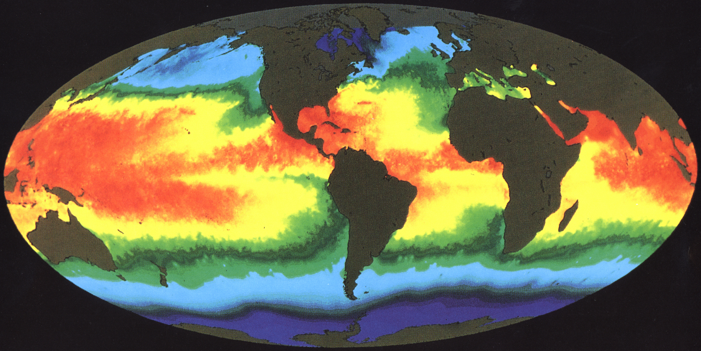
English: This illustration of Earth's sea surface temperature was obtained from two weeks of infrared observations by the Advanced Very High Resolution Radiometer (AVHRR), an instrument on board NOAA-7 during July 1984. Temperatures are color coded with red being warmest and decreasing through oranges, yellows, greens, and blues. Temperature patterns seen in this image are the result of many influences, including the circulation of the ocean, surface winds, and solar heating. The image indicates a large pool of warm water in the Western Pacific and a tongue of relatively cold water extending along the Equator westward from South America. Every few years, there occurs an interrelated set of changes in the global atmospheric and oceanic circulation known as an El Ni±o in which the region of warm equatorial water in the West extends eastward across the Pacific and blankets the cool, productive regions along the coast of South America. Fish, birds, and marine mammals that depend upon the normally phytoplankton-rich waters often die in large numbers during El Ni±o. Images of sea surface temperature such as this help scientists to better monitor and ultimately understand the changes to Earth caused by events such as El Ni±o. |
|||||
| Data | ||||||
| Fonte | Great Images in NASA Description | |||||
| Autore | NASA | |||||
| Licenza (Riusare questo file) |
|

Questa immagine o filmato è stato catalogato dal Goddard Space Flight Center della National Aeronautics and Space Administration (NASA) degli Stati Uniti d'Americacon il Photo ID: GPN-2003-00032 ET Alternate ID: GSST.Questo tag non indica lo status del copyright dell'opera ad esso associato. È quindi richiesto un normale tag di copyright. Vedi Commons:Licenze per maggiori informazioni. Altre lingue:
|
| Annotazioni | Questa immagine è annotata: Vedi le annotazioni su Commons |
Cronologia del file
Fare clic su un gruppo data/ora per vedere il file come si presentava nel momento indicato.
| Data/Ora | Miniatura | Dimensioni | Utente | Commento | |
|---|---|---|---|---|---|
| attuale | 12:14, 1 mag 2015 | | 2 876 × 1 440 (5,31 MB) | Jcpag2012 | crop |
| 02:18, 10 apr 2009 |  | 3 000 × 2 400 (6,22 MB) | BotMultichillT | {{Information |Description={{en|1=This illustration of Earth's sea surface temperature was obtained from two weeks of infrared observations by the Advanced Very High Resolution Radiometer (AVHRR), an instrument on board NOAA-7 during July 1984. Temperatur |
Pagine che usano questo file
La seguente pagina usa questo file:
Utilizzo globale del file
Anche i seguenti wiki usano questo file:
- Usato nelle seguenti pagine di be.wikipedia.org:
- Usato nelle seguenti pagine di ca.wikipedia.org:
- Usato nelle seguenti pagine di crh.wikipedia.org:
- Usato nelle seguenti pagine di en.wikipedia.org:
- Usato nelle seguenti pagine di en.wikiversity.org:
- Usato nelle seguenti pagine di eo.wikipedia.org:
- Usato nelle seguenti pagine di ja.wikiversity.org:
- Usato nelle seguenti pagine di sw.wiktionary.org:
- Usato nelle seguenti pagine di uk.wikipedia.org: