File:German and Japanese spheres of influence at greatest extent World War II 1942.jpg
Vai alla navigazione
Vai alla ricerca

Dimensioni di questa anteprima: 800 × 471 pixel. Altre risoluzioni: 320 × 188 pixel | 640 × 377 pixel | 877 × 516 pixel.
File originale (877 × 516 pixel, dimensione del file: 172 KB, tipo MIME: image/jpeg)
| Questo file e la sua pagina di descrizione (discussione · modifica) si trovano su Wikimedia Commons (?) |

|
Questa immagine (categorizzazione automatica: military map) o tutte le immagini in questa categoria o galleria dovrebbero essere ricreate usando grafica vettoriale come file SVG. Questo offre diversi vantaggi: vedi Commons:Media for cleanup per maggiori informazioni. Se è disponibile una versione in formato SVG di questa immagine, per favore caricala. Dopo aver caricato un file SVG, sostituisci questo avviso con il template {{Vector version available|nome_immagine.svg}}.
|


| Descrizione |
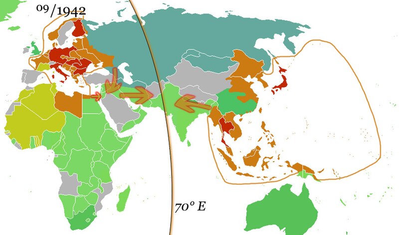
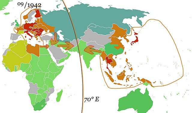
English: The German and the Japanese direct spheres of influence at their greatest extents during the Second World War in fall 1942. Arrows show planned movements to an agreed demarcation line at 70° E, which was, however, never even approximated.
The Allied countries.
Colonies, occupied territories and sphere of influence of the Allies.
The Axis countries.
Colonies, occupied territories and sphere of influence of the Axis
Vichy France and her remaining colonies.
The Soviet Union, its satellite states and sphere of influence.
Neutral countries. Deutsch: Die japanischen und deutschen direkten Einflusssphären während des zweiten Weltkrieges zum Zeitpunkt ihrer größten Ausdehnung im Herbst 1942. Pfeile zeigen geplante Bewegungen in Richtung einer vereinbarten Demarkationslinie entlang 70° östl. Länge, welche jedoch nie auch nur ansatzweise erreicht wurde.
Alliierte
Kolonien, besetzte Gebiete und Einflussbereiche der Alliierten
Achsenmächte
Kolonien, besetzte Gebiete und Einflussbereiche der Achse
Vichy-Frankreich und verbliebene Kolonien
Sowjetunion, ihre Satellitenstaaten und Einflussbereiche
Neutrale Staaten Русский: Немецкая и японская прямые сферы влияния достигли наибольшей степени во время Второй мировой войны осенью 1942 года. Стрелки показывают запланированные перемещения к согласованной демаркационной линии на 70° восточной долготы, которая, однако, никогда даже приблизительно не была определена.
Страны союзников.
Колонии, оккупированные территории и сферы влияния союзников.
Страны «Оси».
Колонии, оккупированные территории и сферы влияния стран Оси
Вишистская Франция и её оставшиеся колонии.
Советский Союз, его государства-сателлиты и сфера влияния.
Нейтральные страны. |
| Data | (UTC) |
| Fonte | |
| Autore |
|
| Questa è una immagine ritoccata, il che significa che è stata modificata digitalmente dalla sua versione originale. Modifiche: Added spheres of influence and 70° E.. La versione originale può essere vista qui: Ww2 allied axis.gif. Le modifiche sono di 36ophiuchi.
|
Io, detentore del copyright su quest'opera, dichiaro di pubblicarla con le seguenti licenze:
| Questo file è disponibile in base alla licenza Creative Commons Attribuzione-Condividi allo stesso modo 3.0 Unported | ||
| ||
| Questo tag di copyright è stato aggiunto nell'ambito dell'aggiornamento della licenza dei progetti Wikimedia. |

|
È permesso copiare, distribuire e/o modificare questo documento in base ai termini della GNU Free Documentation License, Versione 1.2 o successive pubblicata dalla Free Software Foundation; senza alcuna sezione non modificabile, senza testo di copertina e senza testo di quarta di copertina. Una copia della licenza è inclusa nella sezione intitolata Testo della GNU Free Documentation License. |
Puoi scegliere la licenza che preferisci.
Registro originale del caricamento
This image is a derivative work of the following images:
- File:Ww2 allied axis.gif licensed with Cc-by-sa-3.0-migrated, GFDL
- 2010-04-07T22:14:13Z Hohum 1357x628 (106307 Bytes) Reverted to version as of 20:16, 25 November 2009 - problem is the wiki - not the image
- 2010-04-07T22:13:37Z Hohum 1357x628 (594030 Bytes) Reverted to version as of 17:47, 8 May 2009 - attempt to fix thumbnail
- 2009-11-25T20:16:27Z Bruce89 1357x628 (106307 Bytes) Optimised, some of it could be trimmed further
- 2009-05-08T17:47:59Z Rülpsmann 1357x628 (594030 Bytes) Reverted to version as of 08:29, 4 December 2006
- 2009-05-08T17:37:53Z Rülpsmann 1357x628 (594030 Bytes) less confusing, easier to understand if you think
- 2007-09-23T21:28:58Z Parhamr 1357x725 (272876 Bytes) this visual timeline communicates not only the dates but has some "visual context" of the time passed
- 2006-12-30T07:54:11Z Nxx 1357x628 (415308 Bytes) Reverted to earlier revision
- 2006-12-04T08:29:07Z Roke 1357x628 (594030 Bytes) use orange/green colours of original map
- 2006-05-19T04:36:35Z Roke 1357x628 (415308 Bytes) try version with sep 45 map, may not work as had problems
- 2006-05-18T20:04:37Z Roke 1357x628 (394879 Bytes) minor fix of some white lines in one frame
- 2006-05-18T19:38:30Z Roke 1357x628 (394934 Bytes) Western allies (blue), Soviet & allies (red) and Axis including Vichy French (black) during the [[w:Second World War|Second World War]]. Based on GNU image [[:Image:WWII.png]] [[Category:WWII maps (World)]] {{GFDL-self}}
Uploaded with derivativeFX
Cronologia del file
Fare clic su un gruppo data/ora per vedere il file come si presentava nel momento indicato.
| Data/Ora | Miniatura | Dimensioni | Utente | Commento | |
|---|---|---|---|---|---|
| attuale | 12:05, 15 ott 2010 | | 877 × 516 (172 KB) | 36ophiuchi~commonswiki | {{Information |Description={{en|The German and the Japanese direct spheres of influence at their greatest extents during the Second World War in fall 1942. Arrows show planned movements to an agreed demarcation line at 70° E, which was, however, never ev |
Pagine che usano questo file
La seguente pagina usa questo file:
Utilizzo globale del file
Anche i seguenti wiki usano questo file:
- Usato nelle seguenti pagine di af.wikipedia.org:
- Usato nelle seguenti pagine di ar.wikipedia.org:
- Usato nelle seguenti pagine di arz.wikipedia.org:
- Usato nelle seguenti pagine di bcl.wikipedia.org:
- Usato nelle seguenti pagine di be.wikipedia.org:
- Usato nelle seguenti pagine di ca.wikipedia.org:
- Usato nelle seguenti pagine di de.wikipedia.org:
- Usato nelle seguenti pagine di el.wikipedia.org:
- Usato nelle seguenti pagine di en.wikipedia.org:
- Usato nelle seguenti pagine di es.wikipedia.org:
- Usato nelle seguenti pagine di fa.wikipedia.org:
- Usato nelle seguenti pagine di fr.wikipedia.org:
- Usato nelle seguenti pagine di hy.wikipedia.org:
- Usato nelle seguenti pagine di id.wikipedia.org:
- Usato nelle seguenti pagine di ja.wikipedia.org:
- Usato nelle seguenti pagine di kk.wikipedia.org:
- Usato nelle seguenti pagine di ko.wikipedia.org:
- Usato nelle seguenti pagine di lv.wikipedia.org:
- Usato nelle seguenti pagine di mk.wikipedia.org:
- Usato nelle seguenti pagine di nds.wikipedia.org:
- Usato nelle seguenti pagine di nl.wikipedia.org:
- Usato nelle seguenti pagine di ru.wikipedia.org:
- Usato nelle seguenti pagine di uk.wikipedia.org:
- Usato nelle seguenti pagine di uz.wikipedia.org:
- Usato nelle seguenti pagine di www.wikidata.org:
- Usato nelle seguenti pagine di zh.wikipedia.org: