File:Fertiliser, Farming and Ferry - geograph.org.uk - 1737437.jpg
Vai alla navigazione
Vai alla ricerca

Dimensioni di questa anteprima: 800 × 591 pixel. Altre risoluzioni: 320 × 236 pixel | 640 × 473 pixel | 1 024 × 756 pixel | 1 280 × 945 pixel | 2 560 × 1 891 pixel | 3 282 × 2 424 pixel.
File originale (3 282 × 2 424 pixel, dimensione del file: 1,68 MB, tipo MIME: image/jpeg)
| Questo file e la sua pagina di descrizione (discussione · modifica) si trovano su Wikimedia Commons (?) |
Dettagli
| Descrizione |
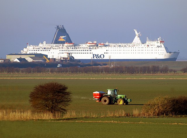
English: Fertiliser, Farming and Ferry, Paull, East Riding of Yorkshire, England. A farmer distributes fertiliser from the back of his John Deere tractor on farmland north of Newton Garth near to the Hedon to Paull road early in the morning. At the same time, North Sea Ferry Pride of York passes on the River Humber just before it berths up outside of King George Dock in Hull. Towards the stern of the boat can be seen Paull Shipyard where a sea-going tug is being built – it is dwarfed by the ferry behind it! The embankment on the side of the Humber hides the river itself, so the ferry looks like a field object in its own right! As a telephoto lens was used for the photograph, the tractor seems to be close to the ferry, but the latter in reality, is well over a mile behind it! The photo was taken from Hedon Flyover |
| Data | |
| Fonte | From geograph.org.uk |
| Autore | Andy Beecroft |
| Licenza (Riusare questo file) |
Creative Commons Attribution Share-alike license 2.0 |
| Attribuzione (richiesto dalla licenza) | Andy Beecroft / Fertiliser, Farming and Ferry / |
| Luogo dello scatto | | Posizione di questa e altre immagini su: OpenStreetMap |
|---|
Licenza

|
Questa immagine proviene dalla collezione del progetto Geograph. Vedi questa fotografia sul sito web di Geograph per visualizzare i dettagli relativi al fotografo. Il copyright di questa immagine appartiene a Andy Beecroft ed è pubblicata secondo i termini della licenza Creative Commons Attribuzione-Condividi allo stesso modo 2.0.
|
Questo file è disponibile in base alla licenza Creative Commons Attribuzione-Condividi allo stesso modo 2.0 Generico
Attribuzione: Andy Beecroft
- Tu sei libero:
- di condividere – di copiare, distribuire e trasmettere quest'opera
- di modificare – di adattare l'opera
- Alle seguenti condizioni:
- attribuzione – Devi fornire i crediti appropriati, un collegamento alla licenza e indicare se sono state apportate modifiche. Puoi farlo in qualsiasi modo ragionevole, ma non in alcun modo che suggerisca che il licenziante approvi te o il tuo uso.
- condividi allo stesso modo – Se remixi, trasformi o sviluppi il materiale, devi distribuire i tuoi contributi in base alla stessa licenza o compatibile all'originale.
Cronologia del file
Fare clic su un gruppo data/ora per vedere il file come si presentava nel momento indicato.
| Data/Ora | Miniatura | Dimensioni | Utente | Commento | |
|---|---|---|---|---|---|
| attuale | 02:21, 13 giu 2010 | | 3 282 × 2 424 (1,68 MB) | File Upload Bot (Magnus Manske) | == {{int:filedesc}} == {{Information |Description={{en|1=Fertiliser, Farming and Ferry, near to Hedon, East Riding of Yorkshire, Great Britain. A farmer distributes fertiliser from the back of his tractor on farmland north of Newton Garth near to the Hedo |
Pagine che usano questo file
La seguente pagina usa questo file:
Utilizzo globale del file
Anche i seguenti wiki usano questo file:
- Usato nelle seguenti pagine di en.wikipedia.org:
- Usato nelle seguenti pagine di fr.wikipedia.org:
- Usato nelle seguenti pagine di no.wikipedia.org:
- Usato nelle seguenti pagine di www.wikidata.org: