File:Dust Storm Over Turkmenistan.jpg
Vai alla navigazione
Vai alla ricerca

Dimensioni di questa anteprima: 800 × 531 pixel. Altre risoluzioni: 320 × 212 pixel | 640 × 425 pixel | 1 024 × 680 pixel | 1 280 × 850 pixel | 3 072 × 2 039 pixel.
File originale (3 072 × 2 039 pixel, dimensione del file: 911 KB, tipo MIME: image/jpeg)
| Questo file e la sua pagina di descrizione (discussione · modifica) si trovano su Wikimedia Commons (?) |
Dettagli
| Descrizione |
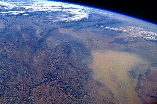
English: This west-looking astronaut photograph, taken with a short focal length lens from the International Space Station, spans a wide swath of central Asia—from Afghanistan, along the length of Turkmenistan, and beyond to the Caspian Sea. Winds blowing down the largest river valley in the region, the Amudarya, were strong enough to raise a large dust storm. Dust appears as a light brown mass extending into the center of the image from the lower right. Diffuse dust from prior windy weather appears over much of the area making a regional haze that hides landscape details. The haze partly obscures the irrigated agriculture in Turkmenistan and entirely obscures the Caspian Sea. Numerous rivers rise in the Hindu Kush range (lower left). The Band-i Amir River is a major tributary of the main regional river, the Amudarya, which it reaches via a deep canyon. The Amudarya River was the major historical contributor of water to the Aral Sea, but today extensive diversion of river water for agricultural purposes has led to desiccation of the sea bed. The exposed sea bed is a major source of saline dusts contaminated with agricultural chemicals, and it poses a significant environmental and human health hazard to central Asia. To a lesser extent, dusts are also mobilized from sediments along the Amudarya River channel. The Paropamisus Range and the Amudarya (also known as the Oxus River) are mentioned in histories of Alexander the Great’s famous military expedition from Greece to India. His horsemen are described as having made a fast side excursion from near the Caspian Sea (image top right) as far as the Amudarya (image lower right).
|
||||||||||||||||||||||||||||||||||||||||||||||||||
| Data | |||||||||||||||||||||||||||||||||||||||||||||||||||
| Fonte | NASA Earth Observatory | ||||||||||||||||||||||||||||||||||||||||||||||||||
| Autore | This image was taken by the NASA Expedition 17 crew. | ||||||||||||||||||||||||||||||||||||||||||||||||||
| Luogo dello scatto | | Posizione di questa e altre immagini su: OpenStreetMap |
|---|
Astronaut photograph ISS017-E-19616 was taken with a Nikon D2Xs digital camera fitted with a 28 mm lens, and is provided by the ISS Crew Earth Observations experiment and Image Science & Analysis Laboratory, Johnson Space Centre.
Questa immagine o filmato è stato catalogato dal Johnson Space Center della National Aeronautics and Space Administration (NASA) degli Stati Uniti d'Americacon il Photo ID: ISS017-E-19616.Questo tag non indica lo status del copyright dell'opera ad esso associato. È quindi richiesto un normale tag di copyright. Vedi Commons:Licenze per maggiori informazioni. Altre lingue:
|
Licenza
| Questo file è nel pubblico dominio perché creato dalla NASA. La politica sul copyright della NASA afferma che «il materiale della NASA non è protetto da copyright a meno che non sia specificato altrimenti». (NASA copyright policy e JPL Image Use Policy). | ||
 |
Attenzione:
|
Cronologia del file
Fare clic su un gruppo data/ora per vedere il file come si presentava nel momento indicato.
| Data/Ora | Miniatura | Dimensioni | Utente | Commento | |
|---|---|---|---|---|---|
| attuale | 11:39, 18 gen 2011 | | 3 072 × 2 039 (911 KB) | Originalwana | higher res |
| 16:56, 26 apr 2009 |  | 1 440 × 960 (597 KB) | Originalwana | {{Information |Description={{en|1=This west-looking astronaut photograph, taken with a short focal length lens from the International Space Station, spans a wide swath of central Asia—from Afghanistan, along the length of Turkmenistan, and beyond to the |
Pagine che usano questo file
La seguente pagina usa questo file:
Utilizzo globale del file
Anche i seguenti wiki usano questo file:
- Usato nelle seguenti pagine di bn.wikipedia.org:
- Usato nelle seguenti pagine di en.wikipedia.org:
- Usato nelle seguenti pagine di en.wikiquote.org:
- Usato nelle seguenti pagine di id.wikipedia.org:
- Usato nelle seguenti pagine di kn.wikipedia.org:
- Usato nelle seguenti pagine di ms.wikipedia.org:
- Usato nelle seguenti pagine di sq.wikipedia.org:
- Usato nelle seguenti pagine di sr.wikipedia.org:
- Usato nelle seguenti pagine di ta.wikipedia.org:
- Usato nelle seguenti pagine di tr.wikipedia.org:
- Usato nelle seguenti pagine di uk.wikipedia.org:
- Usato nelle seguenti pagine di vi.wikipedia.org: