File:Danube delta satelite.png
Vai alla navigazione
Vai alla ricerca
Dimensioni di questa anteprima: 796 × 599 pixel. Altre risoluzioni: 319 × 240 pixel | 638 × 480 pixel | 1 020 × 768 pixel | 1 280 × 964 pixel | 2 560 × 1 928 pixel | 2 720 × 2 048 pixel.
File originale (2 720 × 2 048 pixel, dimensione del file: 11,57 MB, tipo MIME: image/png)
| Questo file e la sua pagina di descrizione (discussione · modifica) si trovano su Wikimedia Commons (?) |
Dettagli
| Descrizione |
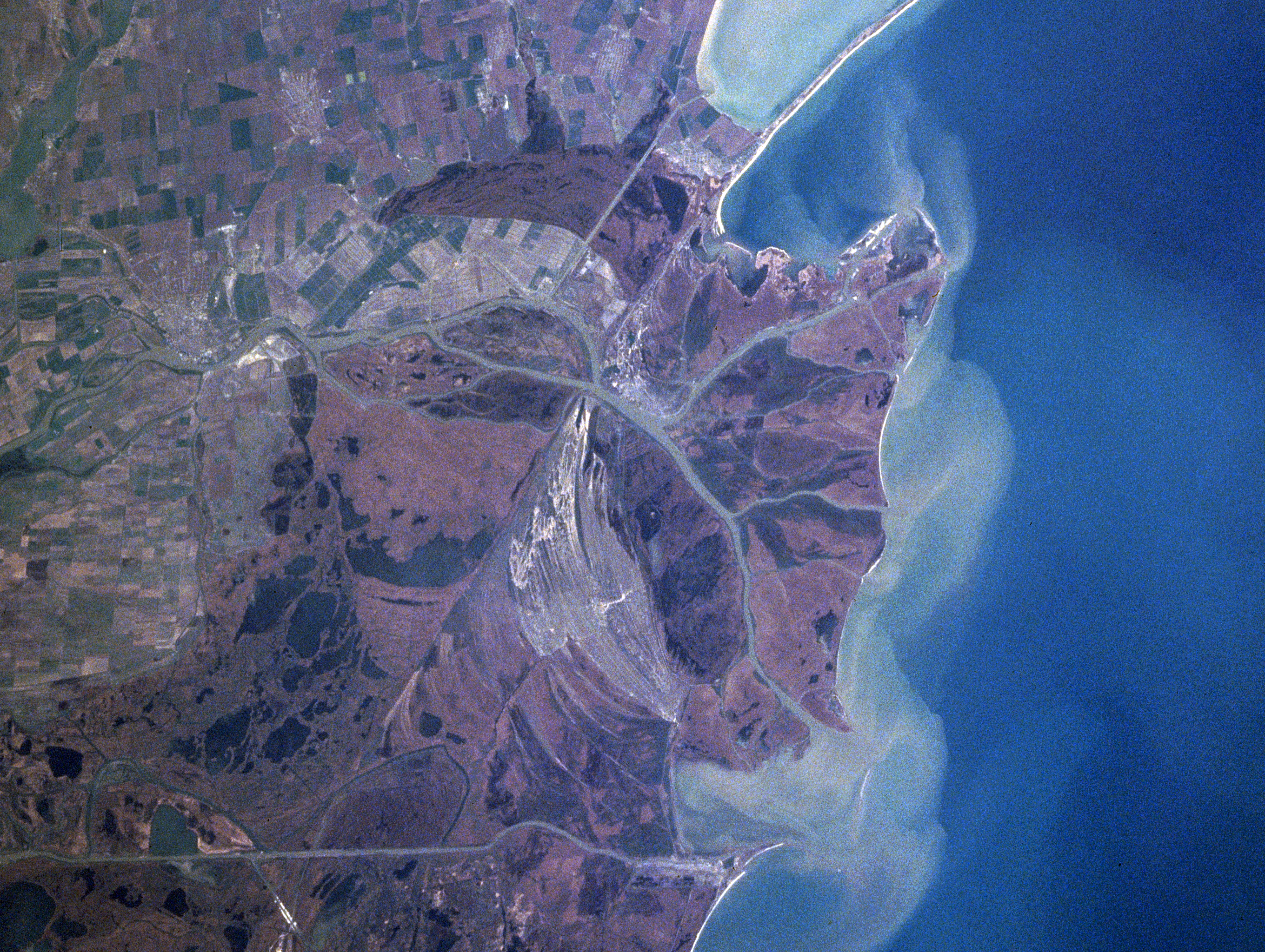
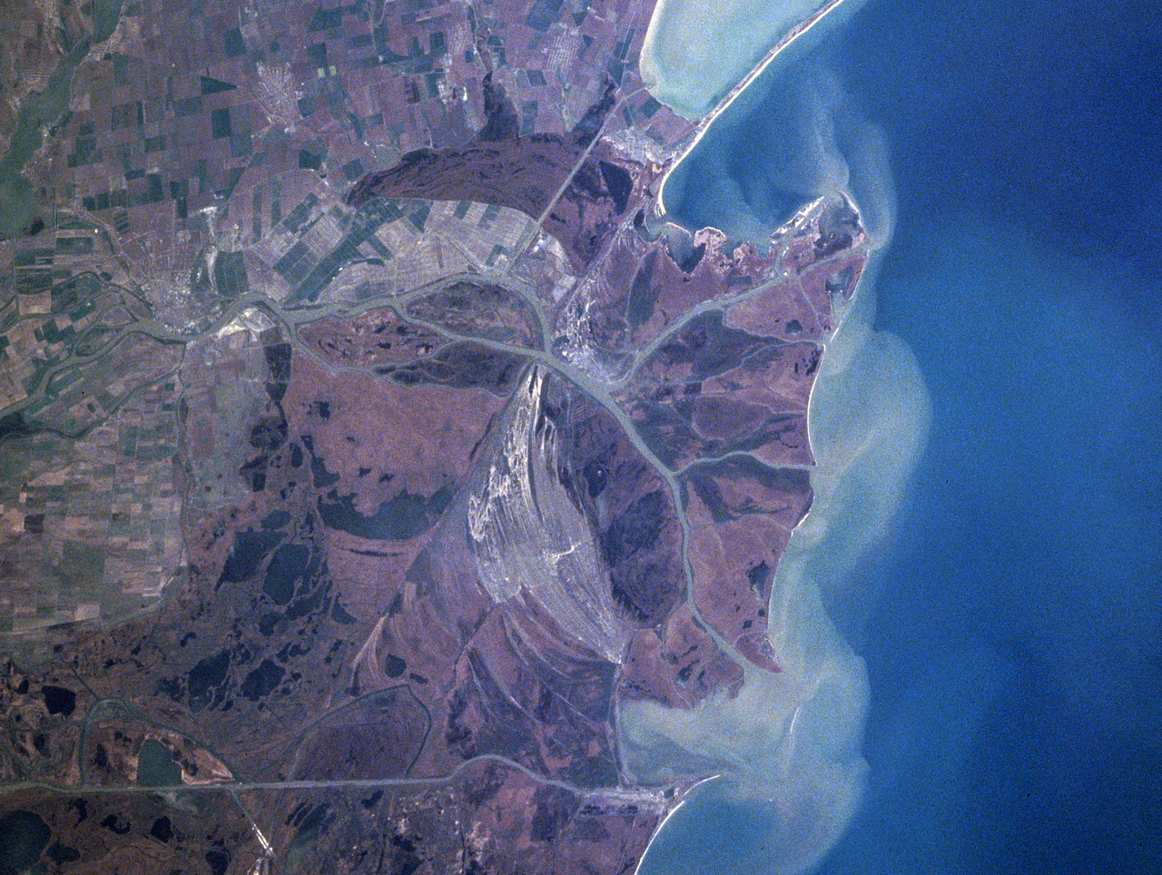
Español: Sector septentrional del delta del Danubio. Se aprecian los sedimentos en suspensión con que se constituye
Foto de satélite (NASA) English: Danube River Delta, Romania/Ukraine Winter/Spring 1998
|
| Data | Scattata il 16 aprile 1998, 12:15:20 UTC |
| Fonte | https://eol.jsc.nasa.gov/searchphotos/photo.pl?mission=NASA7&roll=720&frame=006 |
| Autore | NASA/Mir astronaut |
Questa immagine o filmato è stato catalogato da uno dei centri della National Aeronautics and Space Administration (NASA) degli Stati Uniti d'Americacon il Photo ID: NASA7-720-6.Questo tag non indica lo status del copyright dell'opera ad esso associato. È quindi richiesto un normale tag di copyright. Vedi Commons:Licenze per maggiori informazioni. Altre lingue:
|
Licenza
| Questo file è nel pubblico dominio perché creato dalla NASA. La politica sul copyright della NASA afferma che «il materiale della NASA non è protetto da copyright a meno che non sia specificato altrimenti». (NASA copyright policy e JPL Image Use Policy). | ||
 |
Attenzione:
|
Cronologia del file
Fare clic su un gruppo data/ora per vedere il file come si presentava nel momento indicato.
| Data/Ora | Miniatura | Dimensioni | Utente | Commento | |
|---|---|---|---|---|---|
| attuale | 00:06, 4 feb 2021 | | 2 720 × 2 048 (11,57 MB) | Ras67 | high resolution |
| 03:41, 13 giu 2005 |  | 322 × 243 (43 KB) | Shizhao | Danube Delta satellite photo, source: http://earth.jsc.nasa.gov/sseop/efs/caption.pl?PHOTO=NASA7-720-6 {{PD-USGov-NASA}} |
Pagine che usano questo file
Le seguenti 2 pagine usano questo file:
Utilizzo globale del file
Anche i seguenti wiki usano questo file:
- Usato nelle seguenti pagine di ast.wikipedia.org:
- Usato nelle seguenti pagine di bg.wikipedia.org:
- Usato nelle seguenti pagine di ca.wikipedia.org:
- Usato nelle seguenti pagine di da.wikipedia.org:
- Usato nelle seguenti pagine di en.wikipedia.org:
- Usato nelle seguenti pagine di en.wikivoyage.org:
- Usato nelle seguenti pagine di eo.wikipedia.org:
- Usato nelle seguenti pagine di es.wikivoyage.org:
- Usato nelle seguenti pagine di fr.wikipedia.org:
- Usato nelle seguenti pagine di is.wikipedia.org:
- Usato nelle seguenti pagine di ja.wikipedia.org:
- Usato nelle seguenti pagine di ko.wikipedia.org:
- Usato nelle seguenti pagine di li.wikipedia.org:
- Usato nelle seguenti pagine di lt.wikipedia.org:
- Usato nelle seguenti pagine di nl.wikipedia.org:
- Usato nelle seguenti pagine di nn.wikipedia.org:
- Usato nelle seguenti pagine di oc.wikipedia.org:
- Usato nelle seguenti pagine di pt.wikipedia.org:
- Usato nelle seguenti pagine di scn.wikipedia.org:
- Usato nelle seguenti pagine di sh.wikipedia.org:
- Usato nelle seguenti pagine di simple.wikipedia.org:
- Usato nelle seguenti pagine di sk.wikipedia.org:
- Usato nelle seguenti pagine di sv.wikipedia.org:
- Usato nelle seguenti pagine di uk.wikipedia.org:
- Usato nelle seguenti pagine di vi.wikipedia.org:
- Usato nelle seguenti pagine di www.wikidata.org:
- Usato nelle seguenti pagine di zh.wikipedia.org: