File:Daedelus comparison, remote sensing in precision farming.jpg
Vai alla navigazione
Vai alla ricerca
Dimensioni di questa anteprima: 366 × 598 pixel. Altre risoluzioni: 147 × 240 pixel | 540 × 883 pixel.
File originale (540 × 883 pixel, dimensione del file: 143 KB, tipo MIME: image/jpeg)
| Questo file e la sua pagina di descrizione (discussione · modifica) si trovano su Wikimedia Commons (?) |
| Descrizione |
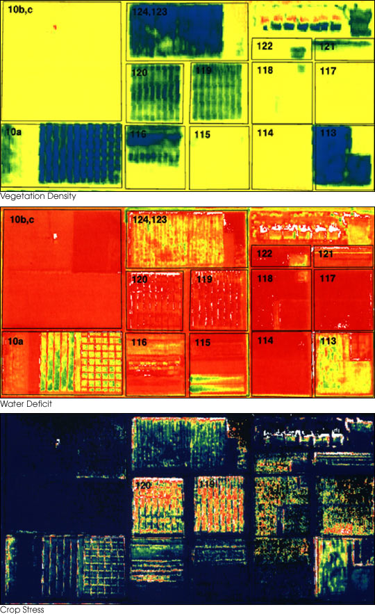
English: These three false-color images demonstrate some of the applications of remote sensing in precision farming. The goal of precision farming is to improve farmers’ profits and harvest yields while reducing the negative impacts of farming on the environment that come from over-application of chemicals. The images were acquired by the Daedalus sensor aboard a NASA aircraft flying over the Maricopa Agricultural Center in Arizona.
|
|||||
| Data | prima del 30 gennaio 2001 | |||||
| Fonte | earthobservatory.nasa.gov (NASA Earth Observatory, Image of the Day 2001-01-30 "Precision Farming") | |||||
| Autore | Susan Moran, Landsat 7 Science Team and USDA Agricultural Research Service (U.S. Government work) | |||||
| Licenza (Riusare questo file) |
|
|||||
| Altre versioni |
.jpg) |

Cronologia del file
Fare clic su un gruppo data/ora per vedere il file come si presentava nel momento indicato.
| Data/Ora | Miniatura | Dimensioni | Utente | Commento | |
|---|---|---|---|---|---|
| attuale | 03:10, 28 giu 2010 | | 540 × 883 (143 KB) | Bdk | {{Information |Description={{en|These three false-color images demonstrate some of the applications of remote sensing in precision farming. The goal of precision farming is to improve farmers’ profits and harvest yields whi |
Pagine che usano questo file
La seguente pagina usa questo file:
Utilizzo globale del file
Anche i seguenti wiki usano questo file:
- Usato nelle seguenti pagine di ar.wikipedia.org:
- Usato nelle seguenti pagine di en.wikipedia.org:
- Usato nelle seguenti pagine di en.wikiversity.org:
- Usato nelle seguenti pagine di eu.wikipedia.org:
- Usato nelle seguenti pagine di fr.wikipedia.org:
- Usato nelle seguenti pagine di id.wikipedia.org:
- Usato nelle seguenti pagine di ja.wikipedia.org:
- Usato nelle seguenti pagine di ko.wikipedia.org:
- Usato nelle seguenti pagine di ms.wikipedia.org:
- Usato nelle seguenti pagine di oc.wikipedia.org:
- Usato nelle seguenti pagine di ru.wikipedia.org:
- Usato nelle seguenti pagine di ta.wikipedia.org:
- Usato nelle seguenti pagine di te.wikipedia.org:
- Usato nelle seguenti pagine di tr.wikipedia.org:
- Usato nelle seguenti pagine di uk.wikipedia.org:
- Usato nelle seguenti pagine di www.wikidata.org: